
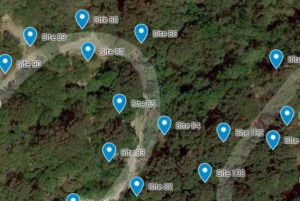
We’ve created a custom map for the First Landing State Park campground, and are in the process of linking each camp site to its description and picture.
Using the map, you can get a visual of your campsite’s proximity to bathhouses, the beach, or other amenities. If you are camping specifically for beach access, look for the sites closest to one of the four boardwalks. If you are looking for privacy and seclusion, zoom in and look for sites that are furthest from other sites, or those closer to the middle of the campground.
The icons are categorized by type of site.
Click on the folder icon on the top left of the map to open the layers. From there, you can filter the icons to display specific categories of campsites.
The water/electric campsites are color-coded to indicate the maximum length of equipment the driveway can accommodate. The length only applies to the maximum length of an RV or trailer can be parked there. You can reserve an RV site even if you are camping in a tent. It is not an indicator of the total size of the campsite. Some of the 50 foot sites have a smaller campsite area than you would expect.
- Burgundy = 50 feet
- Orange = 30 feet
- Yellow = 20 feet
To view a larger version of the map or to search for a specific site, click on the expand icon at the top right of the map.
Virginia State Parks offers a printable pdf map of the campground on their website. and maps are available both at the Information Center at the campground and the Trail Center in the park.